


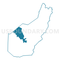
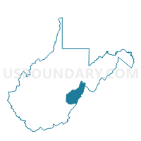
Voting District 12, Pocahontas County, West Virginia
About
Outline

Summary
| Unique Area Identifier | 691689 |
| Name | Voting District 12 |
| County | Pocahontas County |
| State | West Virginia |
| Area (square miles) | 66.11 |
| Land Area (square miles) | 66.04 |
| Water Area (square miles) | 0.08 |
| % of Land Area | 99.88 |
| % of Water Area | 0.12 |
| Latitude of the Internal Point | 38.32320270 |
| Longtitude of the Internal Point | -80.17625020 |
Maps

Graphs
Select a template below for downloading or customizing gragh for Voting District 12, Pocahontas County, West Virginia


Neighbors
Neighoring Voting District (by Name) Neighboring Voting District on the Map
- Voting District 10, Pocahontas County, WV
- Voting District 13, Pocahontas County, WV
- Voting District 15, Pocahontas County, WV
- Voting District 18, Pocahontas County, WV
- Voting District 215, Randolph County, WV
- Voting District 23, Webster County, WV
- Voting District 23, Pocahontas County, WV
- Voting District 26, Pocahontas County, WV
- Voting District 3, Webster County, WV
Top 10 Neighboring County Subdivision (by Population) Neighboring County Subdivision on the Map
- Southern district, Webster County, WV (3,717)
- Edray district, Pocahontas County, WV (3,374)
- Central district, Webster County, WV (2,862)
- Huntersville district, Pocahontas County, WV (1,135)
- Mingo district, Randolph County, WV (794)
Top 10 Neighboring Place (by Population) Neighboring Place on the Map
Top 10 Neighboring Unified School District (by Population) Neighboring Unified School District on the Map
- Randolph County School District, WV (29,405)
- Webster County School District, WV (9,154)
- Pocahontas County School District, WV (8,719)
Top 10 Neighboring State Legislative District Lower Chamber (by Population) Neighboring State Legislative District Lower Chamber on the Map
Top 10 Neighboring State Legislative District Upper Chamber (by Population) Neighboring State Legislative District Upper Chamber on the Map
Top 10 Neighboring 111th Congressional District (by Population) Neighboring 111th Congressional District on the Map
Top 10 Neighboring Census Tract (by Population) Neighboring Census Tract on the Map
- Census Tract 9665, Randolph County, WV (4,558)
- Census Tract 9602, Pocahontas County, WV (3,728)
- Census Tract 9603, Pocahontas County, WV (2,496)
- Census Tract 9703, Webster County, WV (2,269)
Top 10 Neighboring 5-Digit ZIP Code Tabulation Area (by Population) Neighboring 5-Digit ZIP Code Tabulation Area on the Map
- 26288, WV (3,603)
- 24954, WV (3,514)
- 24946, WV (1,533)
- 26208, WV (973)
- 24924, WV (512)
- 26291, WV (165)
- 26282, WV (60)